The sea is rising, Eastbourne will flood – what’s the plan?
Future flooding from the sea is now a reality. There are no clear long-term plans for this. What will this mean for towns like Eastbourne?
bySusan Kerrison, Sussex Bylines
Last year global temperature was estimated to be 1.6 degrees above preindustrial levels. If the world fails to get a grip on carbon emissions, by 2100 the temperature rise could be 4.3 degrees. For Eastbourne, this will mean sea level rises of between 11- 43 inches. These models are reliable as they correlate well with historic data from tide gauges.
Even a moderate increase in sea levels threatens residential and business property. With higher levels, infrastructure like electricity and telecoms, roads, railway lines, and the sewage works at Langney Point are vulnerable.
As well as the sea over-topping the sea defences, the flood water will rise from underneath, inundating the drainage system, washing away the bedding under the roads, and flooding the streets.
Areas such as Roseland and Bridgemere at risk
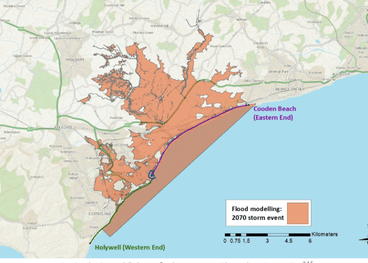
Many low-lying areas of Eastbourne such as Roselands, Bridgemere, Seaside, Langney and Sovereign Harbour will flood putting at risk some 50,000 people, nearly half the population of Eastbourne.
Clearly this is on the Government’s radar as they have set up two projects to begin to address the problems: the Pevensey Bay to Cooden Coastal Management Scheme and Blue Heart.
The Coastal Management Scheme consists, in Phase 1, of reinforcing Eastbourne’s main sea defence, the shingle beach, by modelling the movement of shingle and increasing its replenishment.
At the same time, Blue Heart is investigating how rain, rivers, groundwater, and wastewater move through Eastbourne and South Wealden. This project will then create a water management system using sensor data and weather forecasts to predict flooding.
The policy in Eastbourne has been to “hold the line”
Until now, the policy for Eastbourne has been, as per the 2000 Shoreline Management Plan, to “hold the line”. This means the coastline will be fixed, no matter how much the sea rises. This is the policy for over a third of the UK coastline.
The new Coastal Management Scheme, by contrast, is using an “adaption pathway” which suggests a much more fluid approach. Although a plan until 2037 is being sketched out as the National Audit Office (NAO) notes, no clear longer term plan can be finalised until after the Government’s new spending round in 2027.
This means places like Eastbourne can’t know for some time yet whether they will be one of the government’s priorities for future spending. Will the current progress stall or continue? What will the long-term future of Eastbourne look like?
The Environment Agency (EA) is also playing catch up with the flood waters. The NAO reports that an increased number of properties, 6.3 million, are now at risk, and this could increase to 8 million (25% of all properties) by 2050. At the same time, the latest calculations forecast the number of properties that will be better protected by 2026 at around 40% fewer than that originally planned.
The cost of flood defences
While a new model for assessing flood risk shows more properties in jeopardy, there are also other reasons for this alarming shortfall. Increasing construction costs and more severe weather events, when coupled with budgetary constraints, lead to a back log in the maintenance of existing flood defences.
This raises the question of whether future cost pressures will reduce the maintenance of Eastbourne’s shingle beach. Meanwhile, building is still allowed in high flood risk areas and the number of developments going against the EA flood risk advice is increasing. Local residents will be aware of retirement flats being approved at White Point in Eastbourne right next to the sea.
A further Issue is that the Government expects part of the cost of flood defences to be met by “partnership funding” from local authorities and the private sector. If partnership funding is not forthcoming, however, then some projects may not start.
The situation is exacerbated because local authorities are financially fragile and short-staffed and, although crucial to the delivery of flood management, they will be abolished under the government’s devolution programme in favour of much larger administrative areas.
At the project level, significant parts of the sea defences around Eastbourne, for example, the outer harbour wall, are privately owned by Premier Marinas and, despite concerns about the wall’s maintenance, it is unclear whether a funding commitment has been secured.
It seems that some £800m of the required £2.3bn of partnership funding has yet to be secured. No target has yet been set for the private sector contribution, but the NAO note that only £128m (9%) has been committed.
Will we have to retreat?
Future flooding from the sea is, just one element of the “polycrisis” facing the UK.
The economic and political environment is volatile with a poorly performing economy, the threat of war, deteriorating public services, and declining trust in science. Although the Government has a Climate Adaption Programme, the Committee charged with its oversight, the Climate Change Committee (CCC), is critical of progress.
In its latest report, published in April 2025, the CCC concludes that preparation for adaption is too slow with a lack of a sense of purpose, while coordination and integration into all relevant policies is poor.
Clearly, the lack of a proper plan creates fear and insecurity. Will “holding the line” be possible for over a third of the UK coast? A pessimistic view is that it will prove too costly and difficult to protect towns like Eastbourne against the advancing sea.
“Managed retreat” may have to be considered. This means a planned effort to permanently move people, buildings, and activities away from vulnerable coastal areas like Eastbourne.
What will this require? And, if fair compensation is to be offered to the local community, how much will it cost?


